Article content
The pandemic provided food for thought regarding new approaches to planning and designing cities in a way that allows them to quickly adapt to the risks of new epidemics, as well as meet the urgent needs of citizens in a changing environment.
Smart urban planning prioritizes the human element in designing cities. City residents should have equal and fair access to essential urban services and access to opportunities that provide city, urban amenities, variety, and to other people, that’s why people choose to live in cities.
A 15-Minute City is a residential urban concept in which most daily necessities can be accomplished by either walking or cycling from residents’ homes. It should take no longer than 15 minutes to get from the place where you live to anywhere whether that’s to go to work, to do the shopping, to access healthcare, to entertain. This concept was primarily developed to reduce carbon emissions by reducing the use of cars.
The 15-Minute City is an iteration of the idea of ‘neighborhood units’ developed by American planner Clarence Perry during the 1920s. The theory of ‘new urbanism’, an urban planning and design concept promoting walkable cities, subsequently gained popularity in the US in the 1980s. Similar versions of «urban cells» or 30- and 20-minute neighborhoods have also emerged across the globe in the past decade.
The global COVID-19 pandemic and climate-changing problems accelerated the consideration and implementation of the 15-minute city. In July 2020, the C40 Cities Climate Leadership Group published a framework for cities to «build back better» using the 15-minute concept, referring to plans implemented in Milan, Madrid, Edinburgh, and Seattle after COVID-19 outbreaks. Anne Hidalgo, the mayor of Paris is implementing the 15-minute city concept in Paris.
Geometa allows urban planners to focus on the importance of neighborhood planning.
Today most cities have separate areas used primarily for business or entertainment. Fragmented urban planning results in sprawl, with people having to travel long distances across the city to get to their destination. With Geometa urban planners can bring all the elements for living and working into local neighborhood communities.
Any city benefits or social facilities must be rationally located. This means that the required facility is needed to be located within a radius of convenient pedestrian accessibility from the place of residence, and its capacity is sufficient for everyone.
Expressed in numbers, these parameters are enshrined in local urban planning codes. That means, it is an indicator of how many benefits the city undertakes to provide residents. Each city can have its own unique set of standards, which is formed based on local conditions.
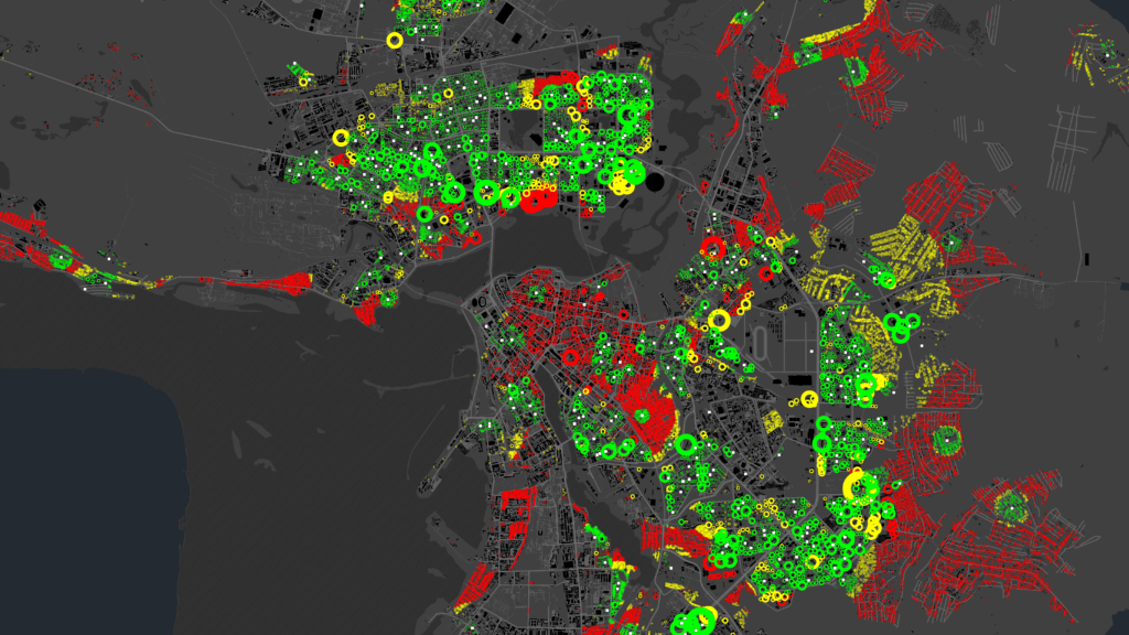
We have developed a tool, which we called «The devouring algorithm». The tool allows assessing the needs of residents in social facilities and modeling transformations. It assesses the availability of social facilities, compares with the standards, and visualizes areas where there is a shortage. It will allow to simulate scenarios, select priority activities, and justify them. Also, it checks the compliance of the actual or planned state of the territory with the requirements of urban planning standards.
How will the quality of life and the load on the territory at a specific point in the city change if a residential building or a kindergarten is built there? Geometa helps urban planning professionals determine how, where, and when their designs can have the greatest impact to improve the quality of life.
How the devouring algorithm works:
- Determines the coverage of the facilities, taking into account the capacity.
- Determines the standard radius of pedestrian accessibility.
- Eliminates double-counting of users in the calculation when the coverage areas of social facilities overlap.
- Visualizes the coverage area and calculates the number of users for any selected social facility.

Geometa designs a decentralized urban planning model, in which each local neighborhood contains all the basic social functions for living and working. This approach will ultimately improve the quality of life, reduce the need for unnecessary travel, strengthen a sense of community and improve sustainability and liveability.


