Benefits
Customize the platform without programming
- Create new data models yourself in the graphical interface
- Automate business processes or develop multi-user applications without changing the code
- Your unique configuration remains compatible with all updates

Create data queries in the visual builder
- Enable more people to build complex database queries
- Combine tables and layers in a query — SQL will be generated automatically
- Use spatial relationships in conditions

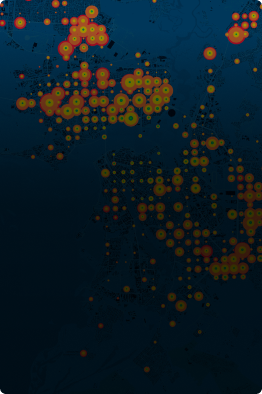
In the photo: provision of residents with places in kindergartens
Work with spatial data
at high speed
- 0.34 seconds to load a map of a million-plus city:
- 1 000 000 objects in a layer
- 500+ layers
- 400 users on the web

×50 regularly updated layers compared to other popular platforms
View historical data
- Access the state of an object for the last few minutes or many years
- Watch how the territory has been changing in space and time
- Evaluate the earlier decisions

In the photo: readiness of construction projects from 2010 to 2021
…and simulate future scenarios
Using devouring algorithms, you can simulate various scenarios for the future development of the territory and decide where it is optimal to establish a park or build a kindergarten.
In the photo: the model of accessibility of parks for residents of the district
We love to understand your city’s challenges
We’re with you all the way. We’ll assist you to get the most out of Geometa with a support approach.
We offer solutions for various industries
Our team has developed dozens of solutions ready for implementation that are in demand in any city and easily adaptable to the specifics and legislation of other countries.

Mapping cases of a disease, defining origination points or high-risk areas, conducting disease awareness-raising campaigns.

Tracking pipelines, managing grids, locating cable and wireless networks, and exchanging information required for construction planning.
The use of Geometa in humanities research and social science helps to examine demographic patterns, population distribution, and social landscape.

Agencies use Geometa to analyze geographic data, such as soils, geology, built data, such as land use, buildings, highways, and infrastructure, and social data.

Improving green spaces and boosting the number of trees on the streets and in parks, managing city beautification projects.

Public safety organizations use Geometa to prevent, quickly respond to and mitigate threats to keep communities and cities safe.