
Article content
Agricultural development is crucial for ensuring food security, struggling against poverty, improving living standards, and making a significant contribution to economic growth. It must come from new technologies which provide sustainable use of natural resources. One such technology could be GIS. The use of geoinformation technologies in agriculture is basically to visualize and analyze land and field data on a map and gain insights based on this data.
Below there are two examples of using Geometa in agriculture.
Precision Agriculture
Project objectives:
- maintaining a map of lands and information about their owners, as well as those who perform sowing and harvesting;
- processing applications for subsidizing the purchase of fuel and maintaining plans for what and when will be sown, monitoring the execution of applications;
- calculation of NDVI according to satellite imagery, field classification, automatic indication of field vegetation deviations from the plan;
- maintaining information on each piece of land, storing history for each piece of land;
- functions for updating data on the boundaries of a piece of land, publishing satellite images from files, and entering data based on the results of checking activities on the land.
Vegetation Classification according to typical NDVI values:

Vegetation change according to NDVI in the period June-August: areas where the index value deviates from the calculated value:

Classification by dominant class (vector):

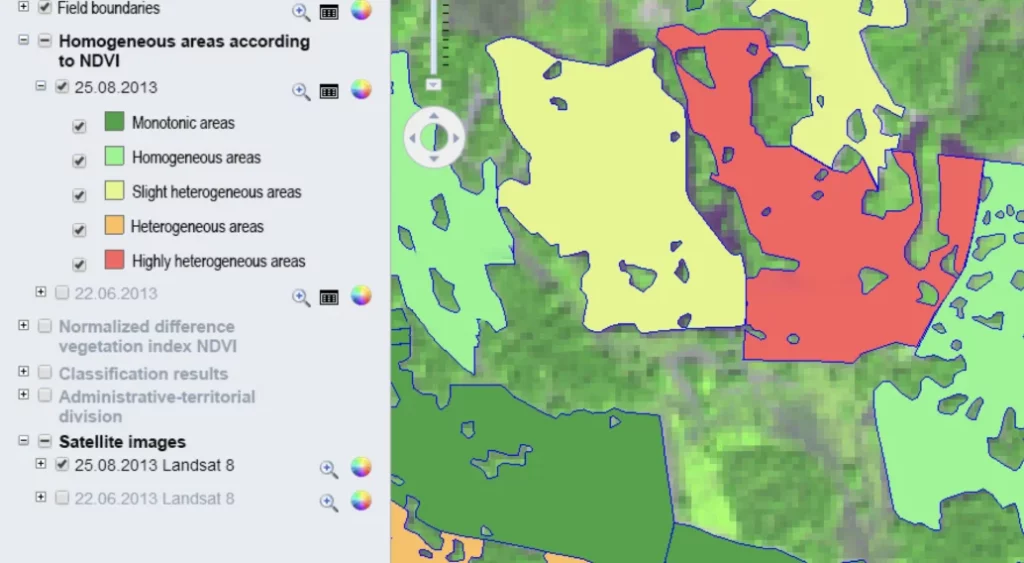
Homogeneity analysis:
Agricultural Land Inventory
Project objectives:
- inventory, classification of all region lands suitable for agriculture;
- maintenance of information on agrochemical indicators of soils;
- maintaining a map of lands and information about their owners;
- selection of zones for more intensive agricultural activities, depending on their indicators;
- formation of land boundaries and interaction with the unified state register of real estate;
- functions for updating data on the land boundaries, publishing satellite images from files, and entering data based on the results of checking activities on the land plot.
Agricultural land inventory:

Identification and mapping of uncultivated agricultural lands using multi-temporal Landsat satellite images:

Agricultural land inventory results:

Inventory of plots on the map:
- Municipality;
- Cadastral value;
- Area;
- Land use type;
- Inventory number of the land plot;
- Owner;
- Land use restrictions;
- Land plot location;
- Soil type;
- Availability of nutrients in the soil;
- Physical and chemical indicators of the soil;
- Indicators of negative processes;
- Availability of nutrients.
Geometa helps easily change the way farmers manage their land and perform their most basic tasks, in order to boost productivity and reduce environmental impacts.


